Why is Ireland divided? Because of decisions taken between 1920 and 1925. Under the Government of Ireland Act 1920, six north-eastern counties, about two-thirds Protestant and mostly unionist, became Northern Ireland, part of the United Kingdom, on 3 May 1921. The other 26 counties became the Irish Free State in December 1922, later the Republic of Ireland. Northern Ireland’s parliament opted out of the Free State the next day, and a 1925 deal kept the border where it was. Under the 1998 Good Friday Agreement, Northern Ireland stays in the UK unless a majority there votes otherwise.
Cross from the Republic into Northern Ireland on a country road and you might not notice. There’s no barrier and no guard. The speed signs switch from kilometres to miles per hour, prices change from euros to pounds, and you’re in the United Kingdom.
That quiet line took more than a decade of crisis to draw. Here’s how it got there, in plain English and without taking sides, and how it works today.
Jump to:
- Who’s who: the words people use
- Where did the divide begin? The Plantation of Ulster
- Home Rule and the 1912 Ulster Covenant
- Why six counties? The Government of Ireland Act 1920
- June 1921: Northern Ireland’s parliament opens
- The Treaty and Northern Ireland’s opt-out
- The Boundary Commission: why the border didn’t move
- From Free State to Republic, and Stormont to the Troubles
- Why is Northern Ireland in the UK but not Great Britain?
- The Good Friday Agreement, consent and border polls
- What is crossing the border like today?
- Partition FAQ
- More Irish history reading
Who’s who: the words people use
- Unionists want Northern Ireland to stay in the United Kingdom. Most people from the Protestant community are unionists.
- Nationalists hope for a united Ireland. Most people from the Catholic community are nationalists.
- Loyalist and republican are narrower: in Northern Ireland they often suggest support for armed groups, says the glossary of CAIN, Ulster University’s conflict archive.
Names divide too. The official name is Northern Ireland, Tuaisceart Éireann in Irish (roughly TOO-ush-kyart AIR-un). Many nationalists, and many people in the Republic, say the North, an Tuaisceart (un TOO-ush-kyart). Some nationalists say the Six Counties, na Sé Chontae (nuh SHAY KHON-tay), a term many unionists dislike. Most unionists say Ulster or the Province, which many nationalists dislike, CAIN notes.
Strictly, Ulster is the old nine-county province, Cúige Uladh (KOO-gyuh UL-uh), and three of its counties are in the Republic.
The southern state’s official name is Ireland, or Éire (AIR-uh); Republic of Ireland, Poblacht na hÉireann (PUB-lukht nuh HAIR-un), is its official description. You’ll often see “Poblacht na h-Eireann” online, but standard Irish writes a small h with no hyphen, and the É keeps its fada. There’s more in what Ireland means.
Northern Ireland’s second city has two names too. Its Irish name, Doire (DIRR-uh), means an oak wood, and it was renamed Londonderry in 1613. Nationalists say Derry, while many unionists now use the official name, Londonderry, says CAIN; before the Troubles, most unionists said Derry too. My guide to Irish place names has more like it.
Even the Irish tricolour nods to the divide: green for the nationalist tradition, orange for the Protestant followers of William of Orange, and white for peace between them.
Where did the divide begin? The Plantation of Ulster
In September 1607, a few years after the Nine Years’ War against the English crown, Ulster’s leading Gaelic lords sailed into exile with almost 100 followers. It’s remembered as the Flight of the Earls. The crown confiscated their lands.
From 1609, James I’s government planned the Plantation of Ulster across six counties: Armagh, Cavan, Coleraine (soon renamed Londonderry), Donegal, Fermanagh and Tyrone. Land went to English and Scottish “undertakers”, former soldiers and officials, the established church and some 208 native Irish freeholders, says historian Raymond Gillespie in History Ireland.
That’s not the same six as today’s Northern Ireland. Antrim and Down weren’t in the official scheme, though private settlement in east Ulster was already well under way.
Over the 1600s, mostly Presbyterian Scots and Anglican English put down deep roots. By 1911, the National Library of Ireland estimates, about 900,000 Ulster unionists were descended from these settlers. Their loyalty to the Crown had limits, the Library adds: in the 1790s many joined the United Irishmen’s rebellion for an Irish republic.
It’s no straight line to partition, though. Far fewer settlers came than planned, Gillespie notes, landlords kept Irish tenants, and the 1630s saw surprisingly little open hostility. Much of the settlement then collapsed in the 1641 rising and the wars that followed, and was rebuilt from the 1660s.
Home Rule and the 1912 Ulster Covenant
From 1 January 1801, under the Act of Union, Ireland was ruled from Westminster as part of the United Kingdom. Home Rule, explains UCD historian Conor Mulvagh in Century Ireland, was the demand to bring government of Irish affairs back to a parliament in Ireland. Ireland would still be part of the UK.
Gladstone’s first Home Rule Bill fell in the Commons in 1886, and the Lords threw out the second in 1893. After the Parliament Act 1911, the Lords could only delay the third, introduced on 11 April 1912.
In Ulster, unionists organised to stop it. The National Library of Ireland gives their reasons: a thriving industrial economy built on linen and shipbuilding, loyalty to the Crown, and fear of a parliament dominated by Catholics, summed up in the slogan “Home Rule is Rome Rule”. Nationalists, who held most of Ireland’s seats at Westminster, wanted it for the whole island.
Ulster Day, 28 September 1912
At Belfast City Hall, the unionist leader Sir Edward Carson signed first. In all, 237,368 men signed the Solemn League and Covenant and 234,046 women signed a parallel Declaration, 471,414 people in total, says the Public Record Office of Northern Ireland. They pledged to resist Home Rule “using all means which may be found necessary”.
You’ll read that some signed in blood. PRONI calls that a myth: there’s no evidence of it, and black ink was the norm.
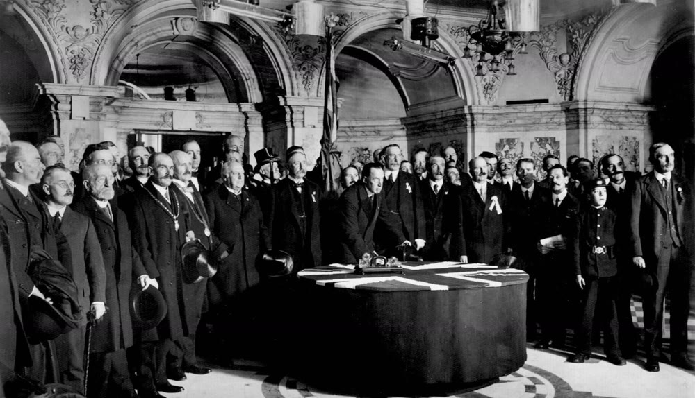
Sir Edward Carson signing the Ulster Covenant at Belfast City Hall, 28 September 1912. Photographer unknown. Public domain, via Wikimedia Commons
Both sides armed. The Ulster Volunteer Force was set up in January 1913 and nationalists formed the Irish Volunteers that November, says CAIN. In April 1914 the UVF landed a large cargo of German arms at Larne, and the Irish Volunteers brought in a smaller one, also from Germany, at Howth that July.
Home Rule finally became law on 18 September 1914, but it was put on hold until the First World War was over, with changes promised for Ulster.
After the 1916 Easter Rising, opinion swung. In the December 1918 election Sinn Féin (shin FAYN, “ourselves”) won 73 seats. In January 1919 its MPs set up their own parliament, Dáil Éireann (DAWL AIR-un, though English speakers usually say “doyle”; dáil means an assembly), as the War of Independence began.
Why six counties? The Government of Ireland Act 1920
London’s answer was the Government of Ireland Act 1920, passed on 23 December 1920. It set up two Home Rule parliaments: one for Northern Ireland (Antrim, Armagh, Down, Fermanagh, Londonderry and Tyrone) and one for “Southern Ireland”, the other 26 counties. A Council of Ireland was meant to work towards a single parliament for the whole island one day.
The Act took effect on 3 May 1921, the date the UK government marks as the creation of Northern Ireland.
Why six counties, not all nine of Ulster? A government committee under Walter Long suggested all nine in late 1919, but ministers gave way to unionist demands for six, says Belfast’s Linen Hall Library. Six was the largest area unionists believed they could hold without risk of a Catholic majority, CAIN explains; there, the 1911 census counted Catholics at about 34 per cent. The price, the National Library notes, was leaving many unionists on the other side, including in Cavan, Donegal and Monaghan.
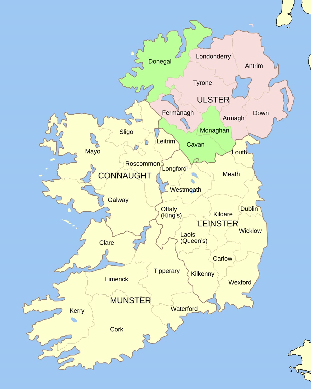
The nine counties of Ulster. The six in pink became Northern Ireland; Donegal, Monaghan and Cavan, in green, are in the Republic. Map: Future Perfect at Sunrise and Hogweard. Public domain, via Wikimedia Commons
Sinn Féin rejected the Act. In the May 1921 elections it won 124 of the 128 southern seats, all unopposed, and treated them as the Second Dáil, so the Southern Ireland parliament never worked as planned. Partition also came amid violence: CAIN counts 501 people killed in Belfast alone between July 1920 and October 1922.
June 1921: Northern Ireland’s parliament opens
Northern Ireland voted on 24 May 1921. Unionists won 40 of the 52 seats, with six each for the Nationalists and Sinn Féin, and Sir James Craig became Northern Ireland’s first Prime Minister. The new parliament first sat on 7 June 1921.
On 22 June, King George V formally opened it in Belfast City Hall. Nationalist and Sinn Féin members stayed away. The King urged all Irishmen “to stretch out the hand of forbearance and conciliation”, as Lisburn Museum records. In July 1921 a truce paused the War of Independence.
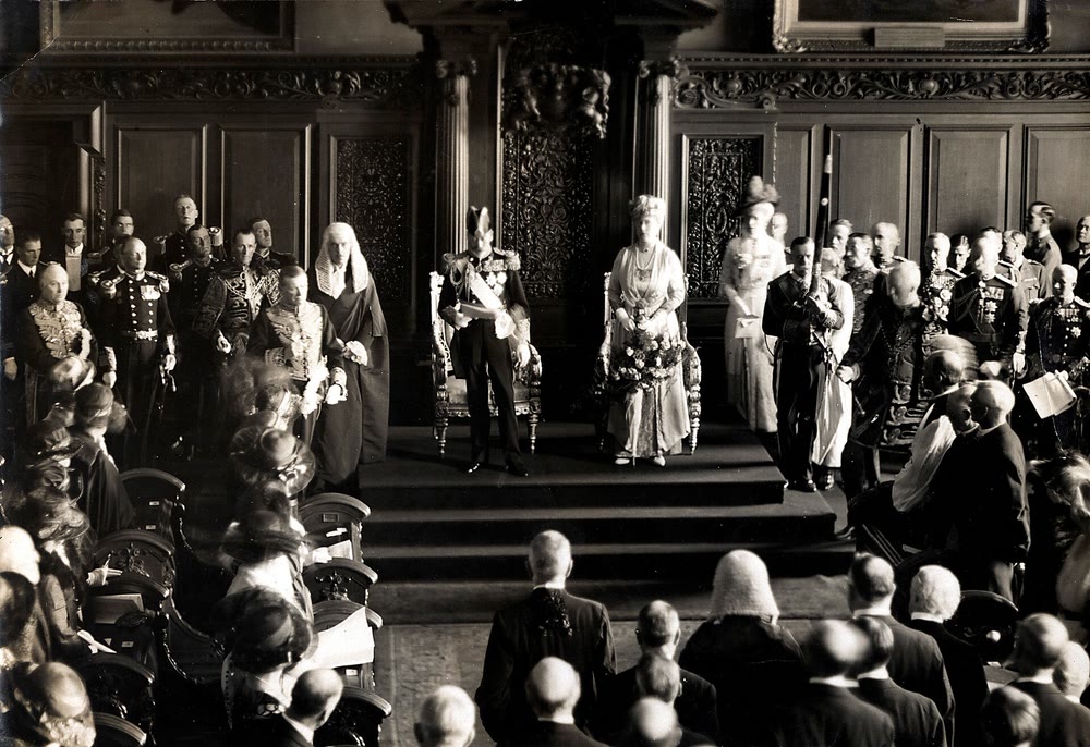
King George V and Queen Mary at the opening of the Northern Ireland parliament, Belfast, 22 June 1921. Photographer unknown. Public domain, via Wikimedia Commons
In 1932 the parliament moved to purpose-built Parliament Buildings at Stormont, on the eastern edge of Belfast. That’s why it’s often simply called Stormont.
The Treaty and Northern Ireland’s opt-out
The Anglo-Irish Treaty was signed in Downing Street on 6 December 1921, with Arthur Griffith and Michael Collins among the Irish signatories. It created the Irish Free State, Saorstát Éireann (SAYR-stawt AIR-un; closer to SEER-stawt in Connacht Irish), a self-governing dominion like Canada. The Dáil approved it by 64 votes to 57 in January 1922, and the split over it led to the Civil War of 1922 to 1923.
Articles 11 and 12 gave Northern Ireland a way out. For a month after the Treaty was ratified, the Free State’s powers wouldn’t reach the North, and if both Houses of the Northern parliament asked the King within that month, it would stay out.
The Irish Free State was born on 6 December 1922. The very next day, both Houses of the Northern parliament unanimously approved the address to the King asking to be excluded. From 1 April 1923, the Free State put customs posts along the new border, the Linen Hall Library notes.
The Boundary Commission: why the border didn’t move
Article 12 had a catch. If Northern Ireland opted out, a three-member commission would redraw the border “in accordance with the wishes of the inhabitants”, as far as economic and geographic conditions allowed. Many nationalists, and the Free State government, expected large areas to move south.
The Free State named Eoin MacNeill. Craig, who saw the 1921 border as permanent, refused to name anyone, so London, which chose the chairman, the South African judge Richard Feetham, also picked Joseph Fisher for Northern Ireland, explains a 2025 House of Commons Library briefing.
Feetham read the Treaty as allowing only fairly small changes. The draft award would have moved roughly 180,000 acres to the Free State and about 50,000 acres the other way. On 7 November 1925 the Morning Post, a London paper, leaked it, map and all. MacNeill resigned on 20 November.
On 3 December 1925 the London, Dublin and Belfast governments signed a deal instead. The border stayed exactly where the 1920 Act had drawn it, the report was shelved, the Council of Ireland was dropped, and the Free State was released from paying a share of the UK’s public debt. The report stayed secret until the files opened in 1968, and it was published in 1969.
From Free State to Republic, and Stormont to the Troubles
In 1937 a new constitution, Bunreacht na hÉireann (BUN-rukht nuh HAIR-un; bunreacht means constitution), claimed the whole island as the national territory in Articles 2 and 3, which angered unionists, CAIN notes. On 18 April 1949 the state left the Commonwealth, and from then on it was described as the Republic of Ireland. Britain answered with the Ireland Act 1949: Northern Ireland would not leave the UK without the consent of its own parliament.
Unionist governments ran Northern Ireland from 1921 until 1972. CAIN notes that many date the start of the Troubles to a Derry civil rights march on 5 October 1968. Stormont was suspended and direct rule from London began on 30 March 1972.
The first border poll, on 8 March 1973, was boycotted by most nationalists; 98.9 per cent voted to stay in the UK, on a 58.7 per cent turnout. CAIN’s Sutton Index counts 3,532 deaths in the conflict between 1969 and 2001.
Why is Northern Ireland in the UK but not Great Britain?
Because Great Britain means England, Scotland and Wales only. The UK’s full name since 1927 has been the United Kingdom of Great Britain and Northern Ireland, so Northern Ireland, home to about 1.9 million people, is in the UK but not in Great Britain, as UK mapping guidance spells out.
Confusingly, “British” often does include Northern Ireland: a UK citizen is officially a British citizen. The same guidance calls Northern Ireland a province; others say country or region.
Identity is mixed. In the 2021 census, 31.9 per cent of people said they were British only, 29.1 per cent Irish only and 19.8 per cent Northern Irish only, reports the Northern Ireland Statistics and Research Agency.
The Good Friday Agreement, consent and border polls
The Good Friday (or Belfast) Agreement was reached on 10 April 1998. On 22 May 1998 it was backed by 71.1 per cent of voters in Northern Ireland and 94.4 per cent in the Republic. Fans of Derry Girls will remember that the show’s finale is set around that vote.
Its heart is consent: both governments accept whatever a majority in Northern Ireland chooses, the Union or a united Ireland.
Under the Northern Ireland Act 1998, the Secretary of State for Northern Ireland may call a poll, must call one if it appears likely a majority would vote for a united Ireland, and can’t hold another within seven years of the last. The Republic’s side changed on 2 December 1999, when new Articles 2 and 3 replaced the old claim: unity can come only peacefully, with the consent of a majority in both parts of the island.
The Agreement also recognises the right of people in Northern Ireland “to identify themselves and be accepted as Irish or British, or both”, and to hold both citizenships. By 2021, 614,300 residents held an Irish passport. If your grandparent was born there, see my guide to Irish citizenship by descent.
What is crossing the border like today?
The land border runs about 310 miles (roughly 500 km). Officials on both sides counted 208 crossing points in 2018, though the true number is disputed, FactCheckNI found. There are no checkpoints, and under the Common Travel Area, British and Irish citizens can live and work on either side.
When the UK left the EU, both sides promised no hard border on the island. Under the Windsor Framework (the Protocol, renamed in 2023), Northern Ireland still follows many EU rules on goods, so the land border stays open and some goods from Great Britain are checked instead, the Northern Ireland Assembly explains. Local parties remain split: the Assembly voted 48 to 36 to keep those rules in December 2024.
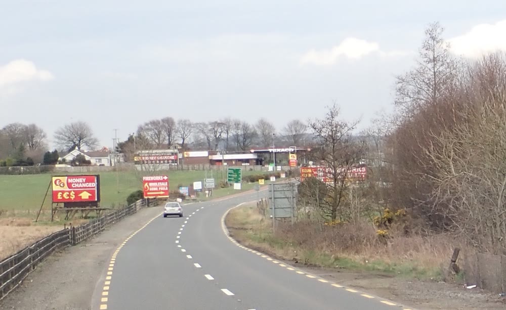
Crossing the border into Northern Ireland on the Dublin Road near Flurrybridge, Co. Armagh, 2018. The yellow road-edge lines used in the Republic stop at the border. Photo: Eric Jones, CC BY-SA 2.0, via Wikimedia Commons
What visitors notice:
- Paperwork: British and Irish citizens need nothing. Most other visitors who don’t need a UK visa, Americans included, need a UK Electronic Travel Authorisation (ETA, £20 in April 2026), even crossing by land, says the Home Office. Legal residents of Ireland from visa-free countries are exempt with proof of residence.
- Money: Northern Ireland uses pounds sterling and the Republic uses euros, says Discover Northern Ireland. Some large stores take euros, but check the rate first.
- Speed: limits are in miles per hour in the North and kilometres per hour in the Republic, which switched on 20 January 2005, RTÉ reported.
For a first trip north, start with my guides to things to do in Belfast and the Giant’s Causeway.
Partition FAQ
Why is Northern Ireland part of the UK and not Ireland?
The 1920 Act created it as part of the UK, and its parliament used the Treaty’s opt-out on 7 December 1922. Today it stays in the UK unless a majority there votes for a united Ireland.
When was Ireland divided?
Partition began on 3 May 1921, when the 1920 Act took effect. Northern Ireland left the new Free State on 7 December 1922, and the border was confirmed on 3 December 1925.
Is Northern Ireland part of Ireland?
It’s part of the island of Ireland but not of the Irish state. Some things still run on an all-island basis: the Ireland rugby team, for one, has never split.
Was Northern Ireland ever part of the Irish Free State?
Historians disagree. FactCheckNI judged that it was technically included for a day or so in December 1922, until the opt-out took effect. House of Commons Library researcher David Torrance argues it never was, even briefly.
Why are Donegal, Cavan and Monaghan not in Northern Ireland?
They’re Ulster counties, but unionists settled for six counties to keep a secure majority. That’s why Malin Head in Donegal, Ireland’s most northerly point according to Discover Ireland, is in the Republic.
Do you need a passport to cross the border into Northern Ireland?
No one checks passports at the land border. Bring photo ID anyway, and if you hold neither a British nor an Irish passport, look up the UK ETA rules before your trip.
Will there be a border poll on a united Ireland?
None has been held since 1973. The Secretary of State must call one if a majority for unity looks likely, and unity would also need a majority in the Republic. In August 2026 UK Prime Minister Andy Burnham called a poll “off the table”, the Irish Times reported; Sinn Féin’s Mary Lou McDonald replied that the right to a referendum is part of the Agreement.
Is Northern Ireland mostly Catholic or Protestant?
Neither has a clear majority now. In the 2021 census, 45.7 per cent belonged to or were raised in the Catholic faith and 43.5 per cent in Protestant or other Christian churches, while 9.3 per cent had no religion either way.
Love this? Save it to your Pinterest board for later.
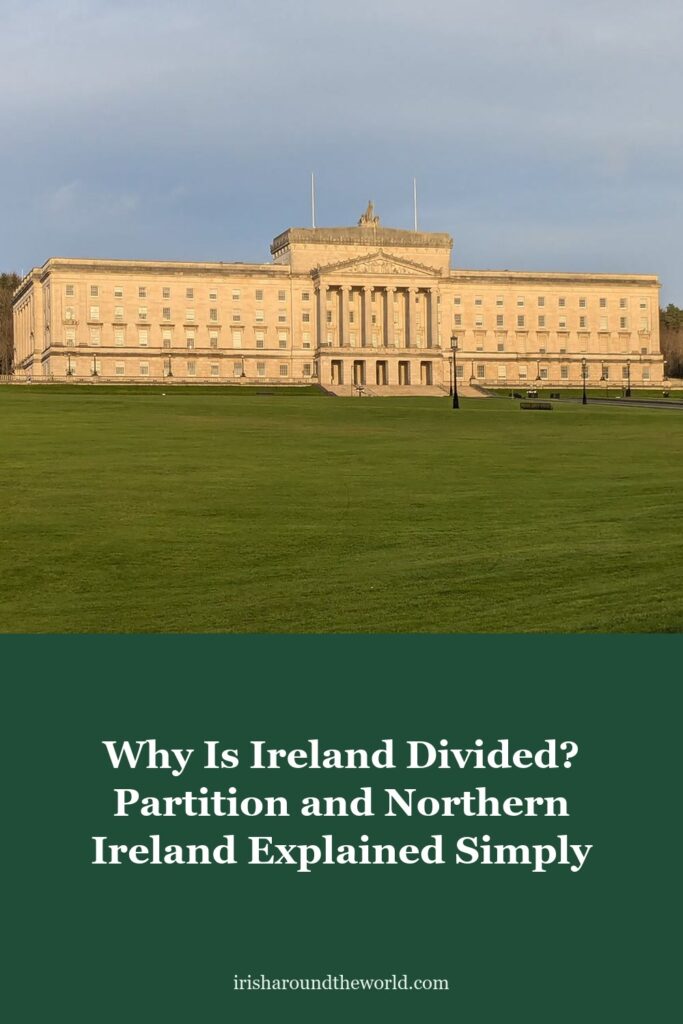
Pin image: Parliament Buildings at Stormont, Belfast. Photo: SamuelLennox, CC0, via Wikimedia Commons
A little bit of Ireland in your inbox every Friday ☘️
The free Weekly Dose of Irish: an Irish joke, a Celtic symbol, an Irish fact, a poem and the week’s best articles in one short email. Join 9,600+ readers.
Free. One short email every Friday. Unsubscribe any time.
More Irish history reading
- The Easter Rising: The 1916 Rebellion That Failed, Then Changed Ireland
- Michael Collins: The Big Fellow Who Helped Run a Revolution, Signed the Treaty and Died at 31
- The Irish Flag: What the Green, White and Orange Really Mean
- Irish Citizenship by Descent: How to Claim It Through a Grandparent (2026)
- Things to Do in Belfast: 10 Best Sights and Day Trips (2026)
Featured image: Parliament Buildings at Stormont, Belfast, home of the Northern Ireland Assembly. Photo: SamuelLennox, CC0, via Wikimedia Commons.