Hy-Brasil, Í Bhreasail in Irish, is the phantom island said to rise off Ireland’s west coast once every seven years. Sea charts showed it from about 1330, Bristol ships went looking for it in 1480 and 1481, and a “Brasil Rock” hung on in some charts into the 1860s or 1870s. Nobody agrees where the name comes from, but it didn’t give Brazil its name: that came from brazilwood. It probably began as a mapmaker’s error, and mirages and fog banks kept people seeing it.
One clear summer evening in 1872, just as the sun went down, a boy looking out to sea saw a dark island appear far offshore. It had two hills, one of them wooded. Between them, on low ground, he could make out towers and wisps of smoke. His mother, his brother and several friends saw it too, and someone cried out that he could see New York.
The boy was Thomas Johnson Westropp, who grew up to be a noted antiquarian. Forty years later he told the Royal Irish Academy that he had seen this illusion about three times as a boy. It had a name, Brasil, and it had sat on sea charts for more than 500 years.
I’ve written about Tír na nÓg, the Land of Youth over the western sea. Hy-Brasil is its stranger cousin, an island that mapmakers and merchants took seriously and hoaxers happily exploited. Here’s its real history.
Jump to:
- What is Hy-Brasil?
- The island on the medieval charts
- Where does the name come from?
- The Bristol voyages of 1480 and 1481
- A magic book and a hoax: O’Brasil in the 1600s
- Hy-Brasil and the Otherworld islands
- How Brasil faded from the maps
- Mirage, fog bank or wishful thinking?
- Hy-Brasil online: the Rendlesham “binary code”
- Where to watch for Hy-Brasil today
- Hy-Brasil FAQ
- More Irish mythology reading
What is Hy-Brasil?
Hy-Brasil is a legendary island in the Atlantic, west of Ireland, also spelled Hy-Breasal, Hy-Brazil, O’Brazil or plain Brasil. In English, say hy-BRAZ-il or hy-BRASS-il: Westropp noted that the island, unlike the country, is stressed on the first syllable of Brasil.
In Irish you’ll see Í Bhreasail (ee VRASS-il) or Uí Bhreasail, which sounds the same; an Irish poem printed in New York’s Irish American newspaper in 1857 calls it Í Breasail. Í is an old literary word for an island, says Ó Dónaill’s dictionary, while Uí (ee) means descendants. English writers spelled Uí as “Hy”, as in John O’Donovan’s Hy-Many (1843), the Uí Maine (ee MAN-yuh) of east Galway and south Roscommon.
The legend says Brasil lies hidden in mist and shows itself once every seven years. The Galway historian James Hardiman noted in 1846 that the people of Aran said so, and Westropp recorded the same belief in 1912, adding that islanders called it the Great Land.
The island on the medieval charts
Brasil appears on paper long before any reliable Irish story mentions it. Its first known outing is on a portolan, a seaman’s chart criss-crossed with compass lines, signed by Angelino Dalorto, or Dulceto, and kept in the Corsini collection in Florence. It was long dated 1325, but the map historian Chet Van Duzer, in a 2026 study, follows the reading 1330. Dalorto is often taken to be the same man as Angelino Dulcert, who drew a chart in Majorca in 1339.
On the 1330 chart, a perfectly round island sits south-west of Ireland, labelled Insula de montonis sive de brazile: the island of montonis (perhaps rams, perhaps mountains), or of Brazil. Dulcert’s 1339 chart puts the same disc in the same place as Insula de Berzil.
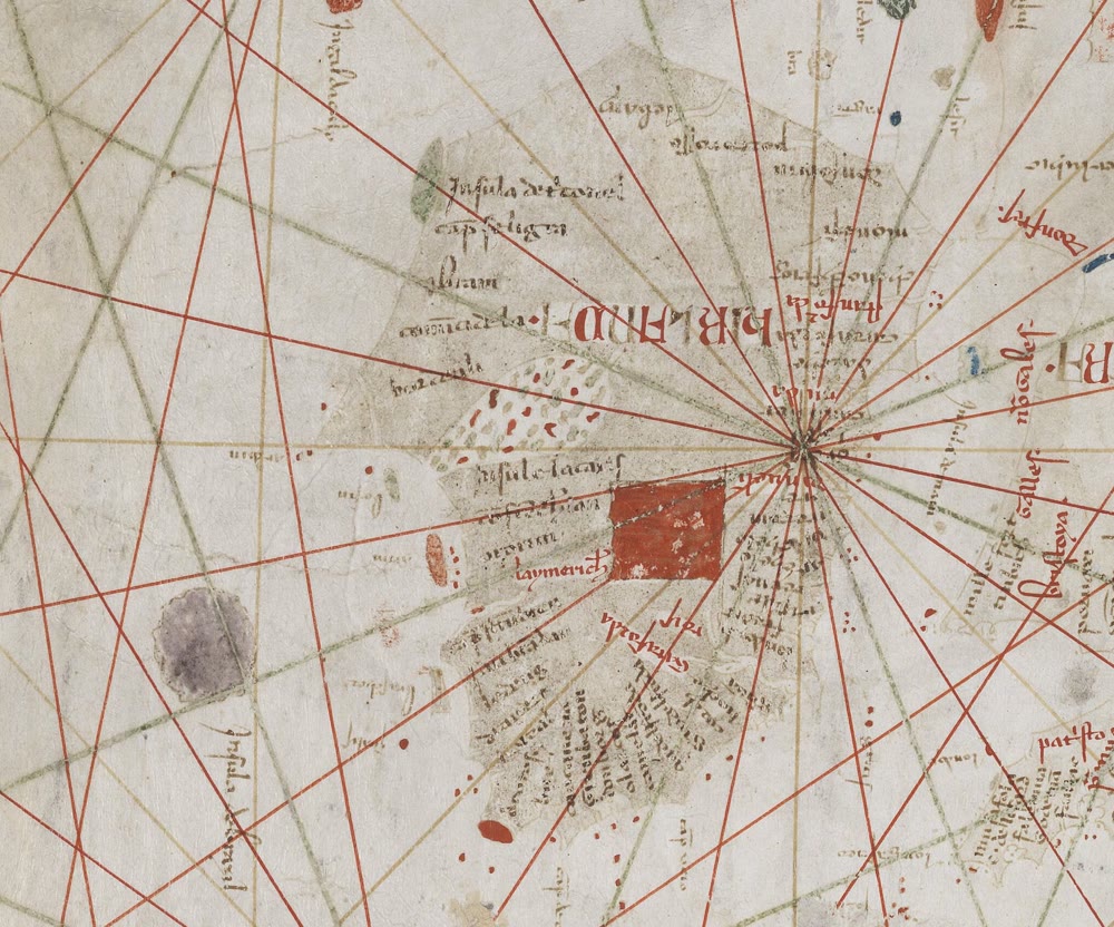
Ireland and the round island of Brasil, labelled Insula de Berzil, on Angelino Dulcert’s sea chart of 1339 (cropped). Bibliothèque nationale de France. Public domain, via Wikimedia Commons
That perfect circle is the puzzle. Van Duzer suggests that a lost chart, made a few years before 1330, had decorative discs where its compass lines met, and a copyist mistook one for an island. It’s a new theory, not settled fact, but it would make Brasil an accident of drawing.
Whatever its origin, it stuck. Andrea Bianco’s chart of 1436 has an Insula de Brasil, and Abraham Ortelius’s map of Europe of 1570 still shows Brasil off the west coast, says the Library of Congress.
Where does the name come from?
Nobody knows, and scholars have argued about it for over a century.
- An Irish name. Bresal, now spelled Breasal (BRASS-ul), was a common early Irish personal name. The Old Irish word bres (bress) could mean a fight, a chief, or beauty and worth, says the Electronic Dictionary of the Irish Language. In a 1922 study for the American Geographical Society, William Babcock thought an Irish root likeliest.
- A red dye. In medieval Europe, brasil was the trade name for red dyewood, much of it from Asia. Babcock found it in an Italian treaty of 1193 and in a 1312 grant of tolls to Dublin, and wondered if Italian mapmakers heard an Irish name and wrote it down as a trade word they knew. The writer Malachy Tallack leans towards the dye; Van Duzer sees no reason to link the two.
- From chart to legend. Barbara Freitag’s 2013 book makes the case in its title: Hy Brasil: The Metamorphosis of an Island: From Cartographic Error to Celtic Elysium. As Tallack sums it up, she found no reliable folklore using the name before the 19th century: the island went from map to myth.
Curiously, ordinary Irish has a word breasal, which Ó Dónaill defines as raddle, rouge or a red stain. And Ó Breasail (oh BRASS-il) survives as a surname, anglicised Brassil or Brazil, found mainly in Waterford and Offaly; History Ireland notes a form of it on record in Co. Cork in 1285, decades before the first chart. There’s more in my guide to Irish surnames.
Did Hy-Brasil give Brazil its name?
No. Pedro Álvares Cabral, who reached the coast for Portugal in 1500, called it the Land of the True Cross. Traders soon named it after the red-dye tree they shipped home, pau-brasil. “Brazilwood gave its name to the country,” says Oxford University’s Plants 400 project.
Roger Casement, then British consul at Belém do Pará, drafted a 1908 essay crediting Ireland with the name, the Irish Times reported in 2026. Historians haven’t followed him: as the Brazilian historian José Murilo de Carvalho points out, no Portuguese writer of the time links the country to the island. In Irish, Brazil is an Bhrasaíl (un VRASS-eel; in Munster the stress moves to the end, un vruh-SEEL).
The Bristol voyages of 1480 and 1481
On 15 July 1480, an 80-ton ship part-owned by John Jay the younger left the Kingroad anchorage at Bristol for the island of “Brasylle” west of Ireland. In September word came back: after about nine weeks at sea they’d found nothing, and storms had driven them into an Irish port.
In July 1481 two small ships, the George and the Trinity, tried again. A customs officer, Thomas Croft, owned an eighth of each, though customs men weren’t supposed to trade. An inquiry that September declared his cargo was not for sale but “to search and find a certain isle called the Isle of Brasile”. He’d also loaded 40 bushels of salt, which suggests they hoped for fishing grounds, wrote the historian David Beers Quinn in the Dictionary of Canadian Biography. What they found, nobody knows.
In 1498 the Spanish envoy Pedro de Ayala reported that for seven years Bristol had sent two, three or four ships a year to look for Brasil and the Seven Cities. Quinn suggested the 1481 ships might even have found land near the Newfoundland fishing banks, before John Cabot’s voyage of 1497. Possible, but unproven.
A magic book and a hoax: O’Brasil in the 1600s
In 1684 the Galway scholar Roderic O’Flaherty wrote that the enchanted island of O’Brasil was often seen from the Aran Islands. In Irish, he said, it was Beg-ara, Little Aran, and it was marked on sea charts. Was it real land hidden by God, or “some illusion of airy clouds appearing on the surface of the sea”, or the work of evil spirits? He couldn’t decide.
Murchadh Ó Laidhe and the Book of Hy-Brasil
O’Flaherty knew a man who said he’d been there. In April 1668, Murchadh Ó Laidhe (MUR-ukh-uh oh LYE; in Connacht, MUR-uh-khoo), Morogh O’Ley in English, was walking alone in Connemara when two or three strangers carried him off by boat to O’Brasil. After two days he was ferried back blindfolded and left near Galway, desperately ill. Seven or eight years later he began practising as a surgeon and physician, though, O’Flaherty insisted, he had never studied either.
Later tellers added that the islanders gave him a book he mustn’t open for seven years, and when he did, he could heal. The book is real: a 15th-century medical manuscript in Irish and Latin, now Royal Irish Academy MS 23 P 10 (ii), the Book of the O’Lees or Book of Hy Brasil, explains the LEIGHEAS project at Maynooth University. The O’Lees were hereditary physicians, and Hardiman suspected Murchadh inherited the book and invented the island to attract patients after losing his lands.
The pamphlet that disenchanted Brasil
In 1675 a London pamphlet, O-Brazile, or the Inchanted Island, printed a letter from Londonderry dated 14 March 1674 (the English year then began on 25 March). It claims a ship of Captain John Nisbet of Killybegs, Co. Donegal, came out of a thick fog beside an unknown shore, where the crew found cattle, horses, black rabbits and a silent castle. When they lit a fire, a hideous noise drove them back aboard.
Next morning an old gentleman explained that their fire had broken a necromancer’s spell. The island was O’Brazile, and the sailors went home with gold and silver coins of an ancient stamp.
It’s almost certainly fiction. Catalogues of early English books attribute it to the writer Richard Head, also credited with a 1674 fantasy, The Western Wonder, or O Brazeel, an Inchanted Island Discovered. Tallack says Captain Nisbet never existed.
Notice the fire. Gerald of Wales, writing about Ireland in the 1180s, describes a “phantom isle” that sank whenever young men rowed close, until they shot a red-hot arrow into it. Westropp recorded a similar fire story about Inishbofin, Co. Galway.
Hy-Brasil and the Otherworld islands
Hy-Brasil seems to belong with Ireland’s older tales of western islands, though they never name it.
- Tír na nÓg (teer nuh NOHG): the Land of Youth, where Oisín spends 300 years.
- Manannán mac Lir (MAN-uh-nawn mok LIR): the sea god and lord of Otherworld islands, one of the Celtic gods.
- The immrama (IM-ruh-muh): voyage tales in which heroes or monks hop from one marvellous island to the next, like the Voyage of Máel Dúin (mail DOON).
- St Brendan: in the Navigatio, St Brendan spends seven years seeking the Promised Land of the Saints, and a St Brendan’s Isle drifted round the old charts alongside Brasil.
Freitag’s research suggests Brasil borrowed the glamour of these tales later. So when you read online that Hy-Brasil was Manannán’s home, or ruled by a High King Breasal, treat it as later embroidery, not ancient lore.
How Brasil faded from the maps
Brasil outlasted Columbus and Cabot, but as more ships crossed the Atlantic, mapmakers grew doubtful. In 1753 Thomas Jefferys, geographer to the Prince of Wales, drew a tiny dotted circle on his Atlantic chart and labelled it “Imaginary Isle of O. Brazil”.
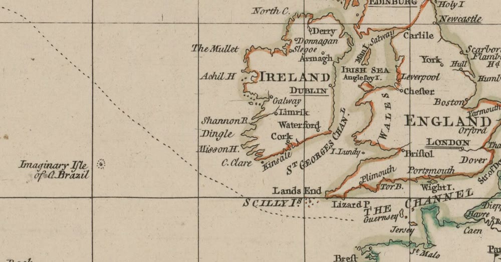
“Imaginary Isle of O. Brazil” off the coast of Ireland, from Thomas Jefferys’ Chart of the Atlantic Ocean (1753, cropped). Bibliothèque nationale de France. Public domain, via Wikimedia Commons
It hung on as Brasil Rock. John Purdy’s Atlantic chart, corrected to 1830, put a high rock at 51°10′ north, 15°30′ west, and the sailing directions repeated a report that an English captain had passed it in 1791, close enough to toss a biscuit ashore. Their later editor, the hydrographer Alexander Findlay, grew doubtful, and Westropp says he struck it off in 1865. The Library of Congress and Tallack give a later date, 1873, for its last appearance, on a British Admiralty chart.
Mirage, fog bank or wishful thinking?
So what were people seeing? O’Flaherty described the Skird Rocks off Connemara, which could look like a city of towers and chimneys or a fleet of ships. Editing him in 1846, Hardiman compared these illusions to the famous Fata Morgana of the Strait of Messina.
A Fata Morgana, named after Morgan le Fay, the enchantress of the Arthur legends, is a superior mirage. When cold air lies on the sea under warmer air, the boundary can act like a lens, bending light from distant objects down to the viewer. Islands and ships, even ones beyond the horizon, can seem lifted into the sky, stretched or flipped upside down, explains Australia’s Bureau of Meteorology.
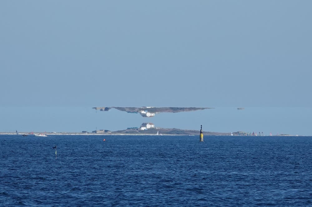
A Fata Morgana between the Glénan islands and Bénodet in Brittany: an inverted copy of the island floats above the real one. Photo: Kervam3, CC BY-SA 4.0, via Wikimedia Commons
Something like this may explain sightings such as Westropp’s, though none can be proved. His own verdict, in his 1912 paper, was that Brasil was purely mythical, or at best mirage and fog bank.
Poets preferred the dream. In Gerald Griffin’s O’Brazil, the Isle of the Blest, quoted by Hardiman, an Aran man sails after the island and never comes home.
Hy-Brasil online: the Rendlesham “binary code”
The newest layer of the legend began in England. In December 1980, US airmen in Suffolk reported strange lights in Rendlesham Forest. The astronomer Ian Ridpath, who investigated for BBC television, traces them to a fireball, the Orford Ness lighthouse and some stars.
In December 2010 one of the airmen, Jim Penniston, said he had written down pages of binary code that came to him telepathically. Fans decoded one line as coordinates in the Atlantic west of Ireland, and the internet decided the spot was Hy-Brasil.
There is no evidence linking any of this to Hy-Brasil. The code isn’t in Penniston’s earliest statements, and binary can be decoded many ways, IBTimes noted in 2026. Colonel Charles Halt, who handled the notebook in 2003, told Ridpath he saw no code in it. File it alongside these other myths about Ireland.
Where to watch for Hy-Brasil today
Go west. O’Flaherty’s Aran Islands are the classic lookout. On Inis Mór (IN-ish MORE), the stone fort of Dún Aonghasa (doon AYN-gus-uh; on Aran, as elsewhere in Connacht, closer to doon EEN-gus-uh) stands on a cliff 87 metres above the Atlantic, with no fence at the edge, so stay well back. On Inis Oírr (IN-ish EER), a limestone chair placed at the request of the broadcaster Charlie Bird invites you to sit, rest and “perhaps see Hy-Brazil”, the Irish Times reported.
Details checked in October 2026, but prices and hours change, so check Heritage Ireland before you go:
- Getting there: ferries sail to Inis Mór from Ros an Mhíl (ross uh VEEL), or Rossaveel, in Connemara and from Doolin, Co. Clare. The fort lies 7 km west of the main village, Cill Rónáin (kill ROH-nawn). From the visitor centre it’s a 1 km walk uphill, ending on rough rock.
- Opening: all year except 24 to 30 December: 9:30 to 18:00 from April to October, 9:30 to 16:00 otherwise.
- Admission: adult €5, senior or group €4, child or student €3, family €13; free if you’re staying overnight in participating accommodation on Inis Mór.
Westropp’s fishermen said they’d seen Brasil from Kilkee in Co. Clare. Both places are on the Wild Atlantic Way. Watch the sunset on a calm, clear evening. You won’t see Brasil, but you might catch a mirage.
Hy-Brasil FAQ
Is Hy-Brasil a real island?
No. It appeared on sea charts from about 1330 and lingered as Brasil Rock into the 1860s or 1870s, but no island has ever been found there.
Does Hy-Brasil appear every seven years?
That’s the folk belief, recorded on the Aran Islands by the 1840s. Mirages and fog banks probably explain the sightings.
Where is Hy-Brasil supposed to be?
West or south-west of Ireland. In the 1800s, Brasil Rock was charted at 51°10′ north, 15°30′ west, roughly 400 km (250 miles) west of Ireland’s south-west tip.
How do you pronounce Hy-Brasil?
In English, hy-BRAZ-il or hy-BRASS-il. The Irish, Í Bhreasail, sounds roughly like ee VRASS-il.
Love this? Save it to your Pinterest board for later.
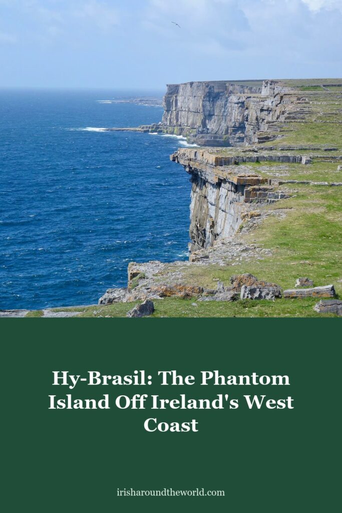
Pin image: Adapted from a photo by Sonse, CC BY 2.0, via Wikimedia Commons.
A little bit of Ireland in your inbox every Friday ☘️
The free Weekly Dose of Irish: an Irish joke, a Celtic symbol, an Irish fact, a poem and the week’s best articles in one short email. Join 9,600+ readers.
Free. One short email every Friday. Unsubscribe any time.
More Irish mythology reading
- Tír na nÓg: The Irish Legend of Oisín, Niamh and 300 Lost Years
- Celtic Gods and Goddesses: 15 Irish Deities and Their Stories
- Did an Irish Monk Reach America 900 Years Before Columbus? The Story of St Brendan
- 20 Myths About Ireland You Probably Believe (And the Truth)
- Wild Atlantic Way Route: Map, Best Stops and 7, 10 and 14-Day Itineraries
- The Táin: How a Royal Bedtime Row Over a Bull Started Ireland’s Greatest Epic
Featured image: The Atlantic cliffs at Dún Aonghasa on Inis Mór, in the Aran Islands, the classic lookout for Brasil. Photo: Sonse, CC BY 2.0, via Wikimedia Commons.